See also: Geography of New York City
Modern redrawing of 1807 version of Commissioner's Grid plan for Manhattan, a few years before 1811 adoption. Central Park is absent. Dark color denotes existing blocks, light gray were planned.
Central Park in the center of satellite image. Manhattan is bound by Hudson River to the west, Harlem River to the north, and East River.
Components
The borough consists of Manhattan Island, Marble Hill, and several small islands, including Randalls Island and Wards Island, and Roosevelt Island in the East River, and Governors Island and Liberty Island to the south in New York Harbor.[103]According to the U.S. Census Bureau, New York County has a total area of 33.6 square miles (87 km2), of which 22.8 square miles (59 km2) is land and 10.8 square miles (28 km2) (32%) is water.[104] The northern segment of Upper Manhattan represents a geographic panhandle. Manhattan Island is 22.7 square miles (59 km2) in area, 13.4 miles (21.6 km) long and 2.3 miles (3.7 km) wide, at its widest (near 14th Street).[105]
Manhattan Island
Manhattan Island is loosely divided into Downtown (Lower Manhattan), Midtown (Midtown Manhattan), and Uptown (Upper Manhattan), with Fifth Avenue dividing Manhattan's east and west sides. Manhattan Island is bounded by the Hudson River to the west and the East River to the east. To the north, the Harlem River divides Manhattan Island from the Bronx and the mainland United States.Early in the 19th century, landfill was used to expand Lower Manhattan from the natural Hudson shoreline at Greenwich Street to West Street.[106] When building the World Trade Center in 1968, 1.2 million cubic yards (917,000 m³) of material was excavated from the site.[107] Rather than dumping the spoil at sea or in landfills, the fill material was used to expand the Manhattan shoreline across West Street, creating Battery Park City.[108] The result was a 700-foot (210-m) extension into the river, running six blocks or 1,484 feet (452 m), covering 92 acres (37 ha), providing a 1.2-mile (1.9 km) riverfront esplanade and over 30 acres (12 ha) of parks.[109]
Marble Hill
One neighborhood of New York County is contiguous with the mainland. Marble Hill at one time was part of Manhattan Island, but the Harlem River Ship Canal, dug in 1895 to improve navigation on the Harlem River, separated it from the remainder of Manhattan as an island between the Bronx and the remainder of Manhattan.[110] Before World War I, the section of the original Harlem River channel separating Marble Hill from The Bronx was filled in, and Marble Hill became part of the mainland.[111]Marble Hill is one example of how Manhattan's land has been considerably altered by human intervention. The borough has seen substantial land reclamation along its waterfronts since Dutch colonial times, and much of the natural variation in its topography has been evened out.[36]
Smaller islands
See also: List of smaller islands in New York City
In New York Harbor, there are three smaller islands:- Ellis Island, shared with New Jersey
- Governors Island
- Liberty Island
- Randalls and Wards Islands, joined by landfill
- Mill Rock
- Roosevelt Island
- U Thant Island (legally Belmont Island)
Geology
Bedrock
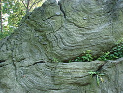
Manhattan schist outcropping in Central Park
Geologically, a predominant feature of the substrata of Manhattan is that the underlying bedrock base of the island rises considerably closer to the surface near Midtown Manhattan, dips down lower between 29th Street and Canal Street, then rises toward the surface again in Lower Manhattan. It has been widely believed that the depth to bedrock was the primary underlying reason for the clustering of skyscrapers in the Midtown and Financial District areas, and their absence over the intervening territory between these two areas.[116][117] However, research has shown that economic factors played a bigger part in the locations of these skyscrapers.[118][119][120]


No comments:
Post a Comment